Photo for 09/11/2006
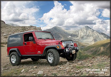
In this photo we are parked just below the summit of Mt. McClellan (near Georgetown and Silver Plume)............. just 15 feet or so behind the Jeep it is about 3,000 feet.... almost straight down! In the background is Gray's Peak (14,270') and Torrey's Peak (14,267').
About 30 feet this side of the Jeep is the old roadbed of the Argentine Central (narrow gauge) Railway as it heads towards the summit of Mt. McClellan (13,587'). The railroad was also known as the Gray's Peak Route. The railroad roadbed continues on up to and elevation of about 13,117 feet. The railroad operated from about 1906-1921. Even though this is an old railroad bed some of the "shortcuts" we have taken to get here are definitely four wheel drive! At times the road is so narrow you have trouble even passing a hiker.....From the turnoff from the pavement on Guanella Pass to the top of Mt. McClellan it 11.5 miles. To do the round trip it took us five hours. Of course that doesn't include the time it took to wash the Jeep on location so it would look good in this photo.. :o) Not really...actually there had been just enough rain in the area to keep the dust settled and there is too much rock for it to be muddy!
posted by Anonymous @ 11:11 PM
0 comments
![]()


0 Comments:
Post a Comment
<< Home